surfer.utils.coord_to_label
-
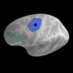
surfer.utils.coord_to_label(subject_id, coord, label, hemi='lh', n_steps=30, map_surface='white', coord_as_vert=False, units='mm', verbose=None)[source]¶ Create label from MNI coordinate
- Parameters
- subject_idstring
Use if file is in register with subject’s orig.mgz
- coordnumpy array of size 3 | int
One coordinate in MNI space or the vertex index.
- labelstr
Label name
- hemi[lh, rh]
Hemisphere target
- n_stepsint
Number of dilation iterations
- map_surfacestr
The surface name used to find the closest point
- coord_as_vertbool
whether the coords parameter should be interpreted as vertex ids
- unitsstr
Can be ‘m’ or ‘mm’ (default).
- verbosebool, str, int, or None
If not None, override default verbose level (see surfer.verbose).